Where to live in London without a car: compare the walks you will repeat
Compare station, park and supermarket walks around West Ealing, Ealing Broadway, Peckham Rye and Brixton before choosing a London home without a car.
By the notbad project · reviewed . Data dates are listed separately.
Compare your everyday walksIn this guide
If you are choosing where to live in London without a car, check the food-shop walk before settling on a short commute. Add the route to somewhere green, and compare all three journeys from the same starting point.
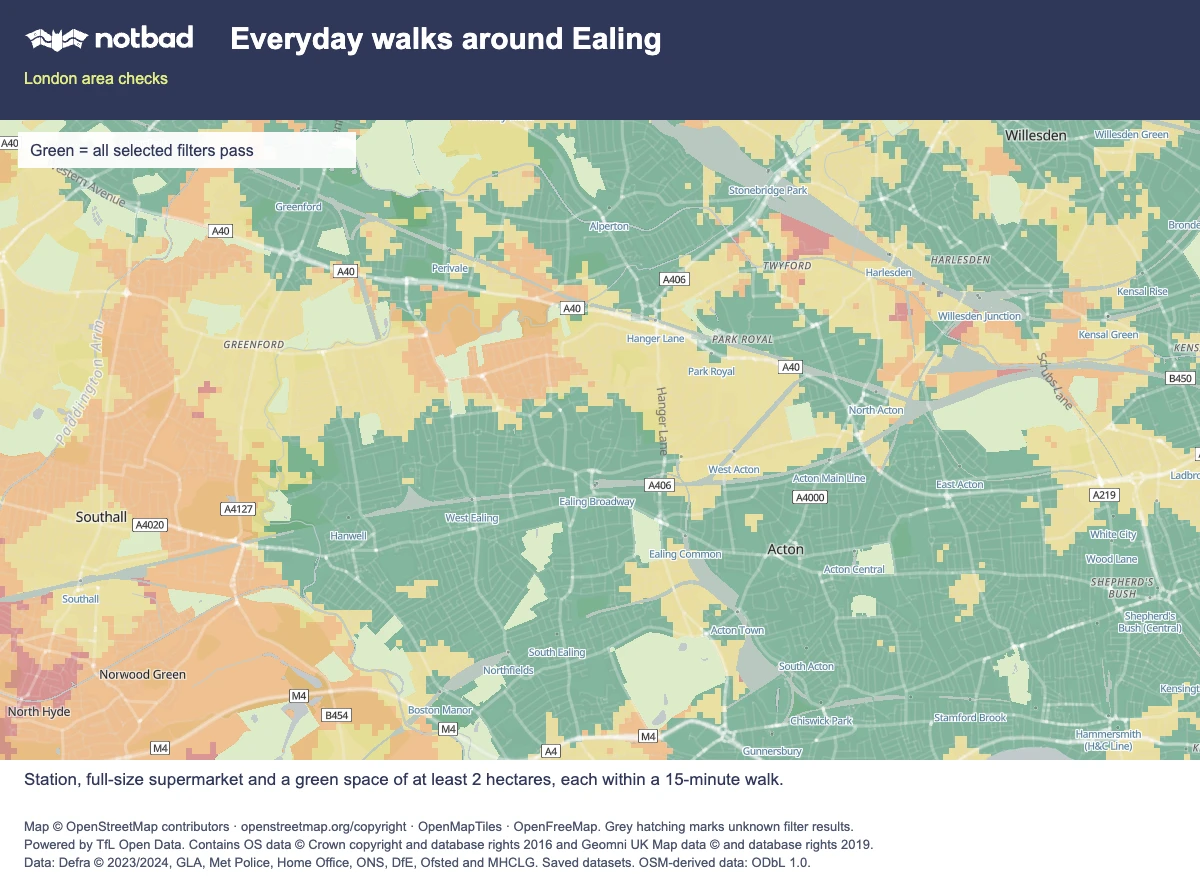
3 applied preferences · green means all selected filters pass
Filters: Walk to a station: 15 min · All supported lines; Walk to green space: 15 min · At least 2 ha; Walk to a supermarket: 15 min · All chains.
Open this exact map searchExample search, not a home recommendation. Saved data may change.
Map © OpenStreetMap contributors · OpenMapTiles · OpenFreeMap. Map and data sources.
Around the West Ealing station point in notbad's saved data, a supported supermarket is about two minutes away and a qualifying green space about six. From the reference point inside Pitshanger Park, also in Ealing, the station walk is about 23 minutes and the supermarket walk about 25.
Four places to start looking, and one useful contrast
| Public reference location | Station access | Green-space access | Supported supermarket access |
|---|---|---|---|
| West Ealing station point | West Ealing, Elizabeth line: about 1 min | Drayton Green: about 6 min | Waitrose: about 2 min |
| Arcadia Shopping Centre point, Ealing Broadway | Ealing Broadway, Central and District lines: about 2 min | Walpole Park: about 5 min | Morrisons: about 1 min |
| Peckham Rye station point | Peckham Rye, Windrush line: at the station reference point | Peckham Rye Common: about 9 min | Lidl: about 4 min |
| Brixton station point | Brixton, Victoria line: at the station reference point | Max Roach Park: about 6 min | Tesco: about 6 min |
| Pitshanger Park reference point | West Ealing, Elizabeth line: about 23 min | Starting point inside Pitshanger Park | Waitrose: about 25 min |
Sources: notbad's Ealing, Southwark and Lambeth example reports. These public map positions include stations and points inside parks; they are not available homes or verified entrances. Every green destination here has at least two hectares of mapped area.
The estimates follow saved streets and paths at 80 metres per minute, with whole minutes rounded down. Access from a property to the street is assumed; your front door, crossings, gates and pace can change the walk. The OpenStreetMap snapshot is from 30 October 2026, so check current openings and access.
West Ealing and Ealing Broadway: two different starting points
West Ealing's Elizabeth line and Ealing Broadway's Central and District lines offer different journeys to work. Both reference points have short walks to a park and supermarket, so the services you need may help you choose between them.
At the Pitshanger Park point, the 23-minute station walk and 25-minute supermarket walk need more thought. A bus, smaller shop or delivery might suit your routine. Work out whether you would rely on those alternatives before searching nearby streets.
Use the Ealing comparison to examine the locations, then check the streets where you can actually find a home.
Peckham Rye: test the food shop as well as the train
From the Peckham Rye station point, notbad estimates a four-minute walk to Lidl and nine minutes to Peckham Rye Common. For a prospective home, check how its position changes both walks.
A flat on the other side of the common would have a different set of walks. The public point inside the common, for example, has an estimated 15-minute walk to Peckham Rye station and 15 minutes to its nearest supported supermarket, a mapped Co-op Food.
Use the two Southwark examples to identify places to visit. Try the shopping route in both directions, considering how it would feel carrying bags, in rain or after dark. Walking times cannot assess those conditions.
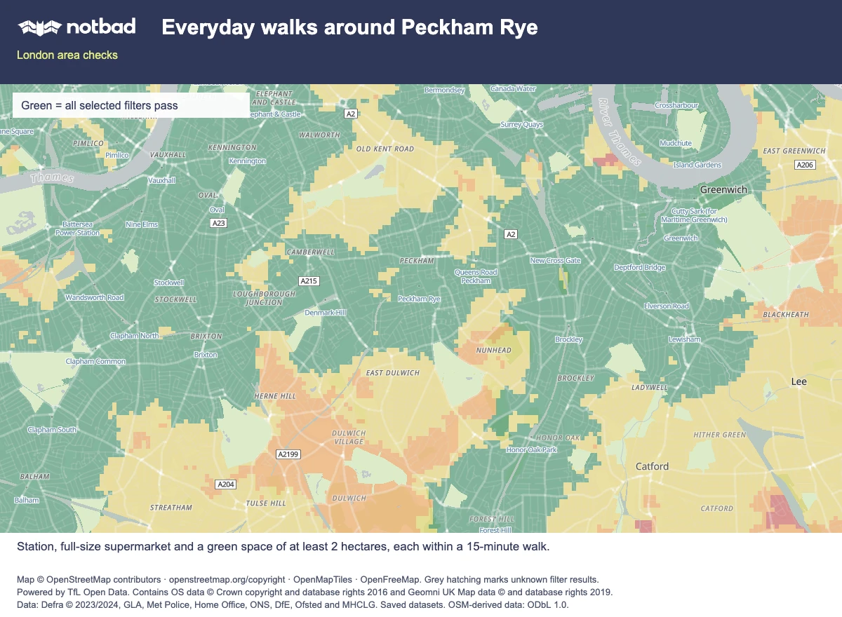
3 applied preferences · green means all selected filters pass
Filters: Walk to a station: 15 min · All supported lines; Walk to green space: 15 min · At least 2 ha; Walk to a supermarket: 15 min · All chains.
Open this exact map searchExample search, not a home recommendation. Saved data may change.
Map © OpenStreetMap contributors · OpenMapTiles · OpenFreeMap. Map and data sources.
Brixton: short walks leave other questions open
At the Brixton Underground station point, both Max Roach Park and the mapped Tesco are about six minutes away on foot. Explore nearby streets if the Victoria line suits your journeys, and check the separate road and railway noise evidence in the Lambeth report.
For a home near transport, listen from the bedroom with the window open as well as shut. Our noise guide explains how outdoor averages can inform that check; they cannot establish whether a room will be quiet. Use the summer viewing checklist to investigate the open-window compromise.
A station walk is only the first leg
Use TfL's journey planner to check the complete trip to your usual destinations, including an evening return. Set the relevant date, time and accessibility options. A short station walk leaves train frequency, interchange time and service reliability to investigate.
notbad covers station walks to Underground, Overground, DLR and Elizabeth line services. Check buses and other National Rail connections separately: an area without a short station walk in this map may still have useful transport.
If your household needs two different lines, use the map's backup-line option. One interchange can provide both; two stations on the same line do not qualify. The station walking guide explains the choices.
Choose a food-shop walk you would actually use
Here, "supermarket" means a supported chain store classified as full size in the saved map data. Recognised compact formats, including Express, Local and Simply Food, are excluded. Classification uses mapped labels, not a floor-area survey.
The comparison does not provide a complete directory of independent grocers or convenience shops. Check what is trading nearby; a smaller shop may meet your needs.
Set separate walking limits for groceries and parks if carrying bags changes what you will accept. Choose a comfortable walk for your household; the 15-minute option is a search preference.
Turn the comparison into a viewing route
On the notbad map, select your useful lines and set station, supermarket and green-space walking limits, plus a minimum green-space size. Apply them together, then investigate prospective homes in the matching areas. A postcode represents several addresses, so refine its point towards the home you are considering.
Before committing, walk the station and shopping routes and find the green-space entrance. Check crossings, access and steps; notbad does not provide step-free routing or check temporary closures. Assess rent and building condition separately, alongside the complete journey to work.
If you are moving with children, the family-home guide adds school-run timing, playground access and bedtime checks to the shortlist.