Hammersmith and Fulham: local evidence before choosing a home
Three public reference positions, ten independent checks and the limitations you need before treating a map result as a housing shortlist.
By the notbad project · editorial review . Source dates are separate.
Explore Hammersmith and Fulham on the mapWhat these local examples show
Goldhawk Road, Ravenscourt Park and Livat Hammersmith provide three distinct supported-station and park combinations. The Ravenscourt Park reference has a lower mapped daytime road average than the Goldhawk Road station reference. Different source-area crime bands appear across all three examples. Compare the actual routes and site approaches rather than transferring one town-centre reading to a nearby home.
This page covers the official Hammersmith and Fulham boundary (E09000013), not a single neighbourhood with the same name. Its three examples are illustrative catalog positions, not a representative sample of homes or a borough-wide verdict.
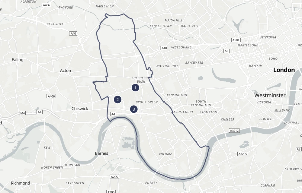
Mapped destinations in this boundary
The retained catalogs place 19 supported station records, 13 named green-space references of at least 2 hectares, 16 supported supermarket records, 8 shopping-centre records and 81 official school positions inside this boundary. These are source-position counts, not a complete inventory or proof of present access; station records can represent separate services at one interchange.
Supported lines represented here: Central, Circle, Hammersmith & City, District, Piccadilly, Mildmay. Coverage includes Underground, Overground, DLR and Elizabeth lines, not every National Rail service. Walking destinations can lie outside the borough.
Three public reference reports
These use the independent Check profile: all supported destination choices, walks up to 30 minutes, green spaces at least 2 hectares, both noise periods and no combined score. School results use all phases and both inspection schemes; the new report-card area is Curriculum and teaching. Origins are source positions, sometimes inside a site, not verified entrances. Unknown means reliable evidence is unavailable, not a pass.
1. Goldhawk Road Underground Station
Station reference · mapped entrance. Coordinates: 51.502005, -0.226715.
Retained source ID: 940GZZLUGHK. A source position is not a surveyed front door or verified entrance.
| Check | Saved evidence at this point |
|---|---|
| Aircraft noise | Daytime: Unknown — no source reading Nighttime: Unknown — no source reading |
| Road noise | Daytime: 67.41 dB Nighttime: 58.07 dB |
| Railway noise | Daytime: 53.69 dB Nighttime: 49.83 dB |
| Tube-track proximity | Within the Tube setback 100 m setback · approximate boundary |
| Station walk | ≈ 1 min walk Goldhawk Road Underground Station mapped entrance |
| Green-space walk | ≈ 5 min walk Shepherds Bush Green 3.4 ha · park |
| Recorded crime | Band 4 / 5 · Higher Hammersmith and Fulham 009B · E01001896 98.7 published crimes / 1,000 residents / year 267 crimes · 2024-09 – 2026-08 |
| School walk | ≈ 6 min walk Flora Gardens Primary School Primary · Community school · Good · legacy overall · 2022-06-09 · mapped school gate |
| Supermarket walk | ≈ 8 min walk Tesco Tesco · Mapped supermarket · store position |
| Shopping walk | ≈ 8 min walk West 12 Shopping centre · mapped centre entrance |
2. Ravenscourt Park
Green-space reference · Mapped green-space reference position; not an entrance. Coordinates: 51.497075, -0.238569.
Retained source ID: 35878624. A source position is not a surveyed front door or verified entrance.
| Check | Saved evidence at this point |
|---|---|
| Aircraft noise | Daytime: Unknown — no source reading Nighttime: Unknown — no source reading |
| Road noise | Daytime: 49.53 dB Nighttime: 42.95 dB |
| Railway noise | Daytime: 53.8 dB Nighttime: 46.92 dB |
| Tube-track proximity | Outside the Tube setback 100 m setback · approximate boundary |
| Station walk | ≈ 6 min walk Ravenscourt Park Underground Station mapped entrance |
| Green-space walk | ≈ 1 min walk Ravenscourt Park 12.3 ha · park |
| Recorded crime | Band 3 / 5 · Middle Hammersmith and Fulham 008D · E01001930 67.4 published crimes / 1,000 residents / year 243 crimes · 2024-09 – 2026-08 |
| School walk | ≈ 5 min walk Ravenscourt Park Preparatory School Not applicable · Other independent school · No linked inspection in the state-funded school snapshot · mapped school gate |
| Supermarket walk | ≈ 6 min walk Co-op Food Co-op · Mapped supermarket · store position |
| Shopping walk | ≈ 15 min walk Livat Hammersmith Shopping centre · centre position |
3. Livat Hammersmith
Shopping-site reference · centre position. Coordinates: 51.493081, -0.227768.
Retained source ID: r7074492. A source position is not a surveyed front door or verified entrance.
| Check | Saved evidence at this point |
|---|---|
| Aircraft noise | Daytime: Unknown — no source reading Nighttime: Unknown — no source reading |
| Road noise | Daytime: 55.35 dB Nighttime: 47.85 dB |
| Railway noise | Daytime: 44.47 dB Nighttime: 37.03 dB |
| Tube-track proximity | Within the Tube setback 100 m setback · approximate boundary |
| Station walk | ≈ 3 min walk Hammersmith (H&C Line) Underground Station mapped entrance |
| Green-space walk | ≈ 11 min walk Ravenscourt Park 12.3 ha · park |
| Recorded crime | Band 5 / 5 · Highest Hammersmith and Fulham 013D · E01001899 386.2 published crimes / 1,000 residents / year 1,222 crimes · 2024-09 – 2026-08 |
| School walk | ≈ 4 min walk St Paul's CofE Primary School Primary · Voluntary aided school · No overall grade under the previous inspection framework · 2024-11-26 · school position |
| Supermarket walk | ≈ 2 min walk Lidl Lidl · Mapped supermarket · store position |
| Shopping walk | ≈ 2 min walk Livat Hammersmith Shopping centre · centre position |
Turn this comparison into viewing questions
Choose the journeys and surroundings you actually need. Check the location of the home, the route and entrance you would use, indoor noise and current access. A missing noise value is unverified quietness; a missing supported-line result does not cover every rail service. Tube proximity does not measure vibration, crime bands do not predict personal safety, and a nearby school does not establish eligibility.
Source snapshots behind these examples
- Aircraft: Defra Round 4 (2022 mapping). Airport activity years vary and are not verified for every airport; missing readings do not establish quietness.
- Road and railway: Defra Round 4 (2022 mapping); 2021 road/rail activity; historical model, not live measurements.. Published values begin at 40 dB day / 35 dB night.
- Walking and mapped destinations: retained OSM snapshot 2026-10-30T21:24:51Z; packaged station snapshot, not live services.
- Crime: 2024-09 to 2026-08; resident population year 2024. Historical London-only bands, not safety grades.
- Schools: GIAS 2026-10-31; Ofsted 2026-09-30. Proximity does not establish admissions.
- Tube proxy: April 2026; 100 m setback, not measured vibration.
Primary source links and licences · Example selection and calculation method